


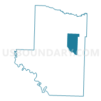
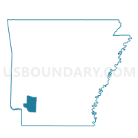
Garland Voting District, Hempstead County, Arkansas
About
Outline

Summary
| Unique Area Identifier | 526600 |
| Name | Garland Voting District |
| County | Hempstead County |
| State | Arkansas |
| Area (square miles) | 29.46 |
| Land Area (square miles) | 29.36 |
| Water Area (square miles) | 0.10 |
| % of Land Area | 99.65 |
| % of Water Area | 0.35 |
| Latitude of the Internal Point | 33.78689690 |
| Longtitude of the Internal Point | -93.54776350 |
Maps

Graphs
Select a template below for downloading or customizing gragh for Garland Voting District, Hempstead County, Arkansas


Neighbors
Neighoring Voting District (by Name) Neighboring Voting District on the Map
- DeRoan Voting District, Hempstead County, AR
- Noland Voting District, Hempstead County, AR
- Ozan Voting District, Hempstead County, AR
- Wallaceburg Voting District, Hempstead County, AR
Top 10 Neighboring County Subdivision (by Population) Neighboring County Subdivision on the Map
- De Roan township, Hempstead County, AR (13,406)
- Ozan township, Hempstead County, AR (1,337)
- Wallaceburg township, Hempstead County, AR (940)
- Noland township, Hempstead County, AR (434)
- Garland township, Hempstead County, AR (366)